


The Canada Park region has become completely Israeli in at least two ways: 1) It was “annexed” to Israel and “naturalized.” No signage indicates it’s located beyond the Green Line, there’s almost no trace of the Palestinian villages Israel captured and demolished during the 1967 war and an attractive Keren Kayemeth LeIsrael (KKL) forest has been planted serving thousands of visitors annually. 2) Israel never agreed in negotiations with Palestinians to relinquish the area; the Zionist leadership expects it to remain part of Israel. [1] (Editor’s Note: The Keren Kayemeth LeIsrael is the Israeli arm of the Jewish National Fund.)
Zochrot was born in Canada Park in 2001 because KKL signs made no mention of ‘Imwas and Yalu, villages on whose ruins the park was established. [2] Since then the organization has conducted many activities and led many tours in the area, the most recent of which was part of the “New KKL” exhibit Moran Barir and I mounted in the Zochrot Gallery, March-May 2014. The most notable part of the exhibit was a huge map of the Canada Park area, 4 x 5 meters in size, on the gallery floor.
This is the fourth map I’ve created. [3] All of them are oppositional, opposed to the usual, existing Israeli maps. As such, they’re utopian maps (maps of “no-place”) or maps of lost locations that will no longer exist. I want to emphasize that I’m writing as an “Israeli;” I don’t pretend to engage in a comprehensive discussion of all the possible ways this part of the Latrun area can be viewed.
Harmonized Maps
A quick Hebrew internet search returns various maps of Canada Park. What they share is the absence of the Palestinian villages destroyed by Israel in 1967, immediately after the war. Nor do most of them show the Green Line, the international border established in the 1949 Armistice agreement between Israel and Jordan.
Here are three examples:
A map of Israeli nature and landscape sites:
 Wikipedia in Hebrew:

Trekker:
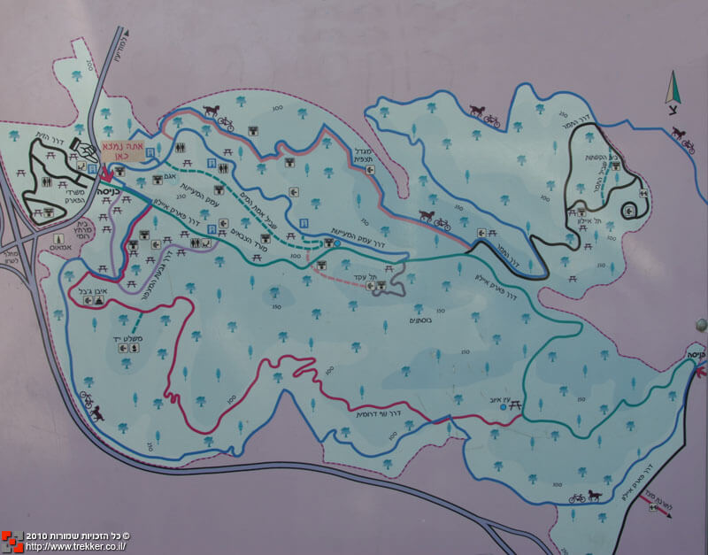
These Hebrew maps show the Park Canada area, referring to its history during the biblical (Tel Ayalon), Roman (‘Imwas and its bathhouse) and Crusader (ruins of a fortress) periods and during the 1948 war (a memorial to the fighters and the capture of Deir Ayoub). Christian religious sites (a monastery) also appear on the map.
I propose to read these maps as an example of what Herbert Marcuse called “negatively present”. [4] These maps are a very good example of the specific “environmental” forces which precondition his mind for the spontaneous repulsion of certain data, conditions, relations. [5] The Israeli reader is exposed to these maps, and to a similar map placed by the KKL in the park itself, and they become part of the environment that structures our mental world, our spatial understanding, but one which lacks “certain data,” the presence here of Palestinians.
Marcuse seeks “Critics’ thought strives to define the irrational character of the established rationality (which becomes increasingly obvious) and to define the tendencies which cause this rationality to generate its own transformation.” [6] Analysis of these maps shows they contain their own negation by concealing the drama which took place in the location they describe.
A critical reading of these maps exposes “harmonizing consciousness and its false realism.” [7] The maps’ harmony is created by presenting an historical continuum which doesn’t discomfort the Israeli reader’s consciousness: first came the biblical landscape (which is ours!), then the Romans, the Crusaders and the Arabs, whom we fought in 1948, and we remember our fallen in that battle. And yes, there are also Christian churches in the country.
This flow of history concludes with the establishment of the state in 1948, structuring the location as “Israeli” since that moment, forgetting it had been captured by Israel only in 1967. But even a superficial investigation exposes the false harmony of these representations, these maps, exemplifying their self-undermining negativity.
Why do these maps, like the signs in the park, conceal the Palestinian villages’ history? I can’t be certain, but the preceding analysis suggests those who carried out the Israeli mapping fear inclusion of information about the conquests which followed the state’s establishment might undermine their legitimacy in the eyes of some Israeli visitors to the park. The 1948 conquests are viewed by most Israelis as existential necessities, a “natural phenomenon” required for the establishment of the state, requiring no justification. But the territory captured in 1967 is not an integral part of the state even from the perspective of Israeli law. Representing the demolished villages on the Hebrew maps raises questions about the circumstances of their capture and their demolition and exposes the fact they were destroyed not in the heat of battle but as the result of a strategic decision to demolish them and never relinquish that territory.
A reverie’s disturbing map

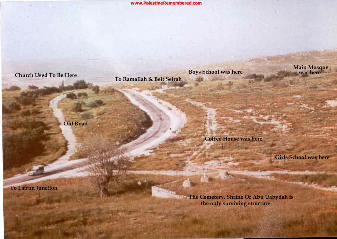
The map I created for the New KKL structures a space which is largely foreign to Israelis, even those who’ve been to Canada Park and know it well. Perhaps they will find it particularly strange because, seemingly out of nothing, three red stains representing the villages of ‘Imwas, Yalu and Beit Nuba destroyed by Israel in 1967 and which the park almost completely ignores even though it contains their hidden remains. To aid in orientation, I included on the map Highway 1, Latrun junction and a photo of the huge entry sign the KKL erected at the park’s entrance on Highway 3. The additional elements on the map are almost unknown to Israelis, in particular the reference to those villages which were home to their inhabitants until they were uprooted in 1967. My map isn’t intended to represent the reality revealed to the park’s Israeli visitor, but what Israel wants to erase from it.
The combination of familiar elements which aid in orientation and those unfamiliar to most Israelis creates a montage, as described by Walter Benjamin:
The principle of construction is that of montage, whereby the image’s ideational elements remain unreconciled, rather than fusing into one “harmonizing perspective.” For Benjamin, the technique of montage had “special, perhaps even total rights” as a progressive form because it “interrupts the context into which it is inserted” and thus “counteracts illusion” [8]
This new map creates discordance, not harmony. The reference to the park is accompanied by traces of the destruction and expulsion of the Palestinians in 1967. The map’s prominent Green Line recalls the controversial legitimacy of Israel’s claim to the area. As part of the New KKL project I surveyed 200 visitors to the park; most were very surprised when I told them they were standing beyond the Green Line. A young couple who’d participated in the survey ran into me a few hours later; they said they were still thinking about what I’d told them. It’s not by accident this information doesn’t appear on KKL signs and maps in the park. It’s disquieting information which, as Benjamin writes, operates in opposition to illusions.
The map won’t help you get around – it makes it harder. It takes the Israeli user on a trip to an imaginary reality – denied, repressed. It doesn’t represent reality, as a map should presumably do, but creates an imagined representation of an archeological journey into the Israeli colonialist past to conjure its ghosts whose traces can be found on the park’s land, visible to anyone who makes the effort to see them.
The “dialectical image,” another of Benjamin’s concepts, helps explain this new map. Before trying to understand the concept, let’s take a moment to consider its origin. He writes:
As an immediate, quasi-mystical apprehension, the dialectical image was intuitive. As a philosophical “construction,” it was not. [9]
That’s how I created the map. Even though I’d thought about it for a long time, the moment of its birth was pretty intuitive. The moment when I decide what to include and what to erase isn’t the result of a reasoned thought process and intensive consideration but of a flash of editorial insight while facing a computer screen and the need to answer the graphic designer’s question – leave it in, or take it out?
In that moment everything I’ve learned during years of research and action comes together, but I’m particularly drawn to the chaotic-mystical nature of the moment in which the decisions can’t be fully justified. What I’m doing now, in writing, is attempting to understand my own behavior, to learn what happened to me, which I didn’t completely understand when it occurred.
Susan Buck-Morss describes Benjamin’s idea of the dialectical image thus:
Benjamin’s laborious and detailed study of past texts, his careful inventory of the fragmentary parts he gleaned from them, and the planned use of these in deliberately constructed “constellations” were all sober, self-reflective procedures, which, he believed, were necessary in order to make visible a picture of truth that the fictions of conventional history writing covered over. [10]
That’s also how “my” map was created. It contains elements gathered over the course of many years. Other elements weren’t included so the map would clearly and precisely meet the needs of the project of which it formed a part. It displays the true picture which existing maps conceal. The expression “covered over” exposes the dual concealment: of the truth about the park on the maps, and by the KKL’s trees planted on the ruins of the Palestinian villages.
In Benjamin’s own words:
In the dialectical image, the past of a particular epoch [. . .] appears before the eyes of [. . . a particular, present epoch] in which humanity, rubbing its eyes, recognizes precisely this dream as a dream. It is in this moment that the historian takes upon himself the task of dream interpretation. [11]
This map could be seen as a dream, something taking place in the Israeli unconscious, but one must insist on its reality and its truth because, like a dream, it’s hard to believe in its veracity. The critical historian and cartographer becomes an interpreter of dreams, perhaps even their author, a kind of mythologist.
But Benjamin doesn’t intend to allow us to be overcome by illusions and dreams like the surrealists:
(…)”not to let oneself be lulled sleepily within the ‘dream’ or ‘mythology,'” but “to penetrate all this by the dialectic of awakening.” … is concerned with dissolving mythology into the space of history.” [12]
The dialectic of the image of the New KKL map lies in the combination of a disappeared, denied, concealed reality – and in that sense dreamlike, mythological – with the effort to return it to history as an undeniable truth. This map dredges from the Israeli subconscious that which has been denied, lays on the threshold of consciousness the fact of the conquest and expulsion of people from their homes in violation of international law and of Jewish and universal morality.
In the present context, with the Israel-Palestine conflict still at its height, this map becomes a part of the discussion. It doesn’t only deal with the argument about the past, and that’s its political significance. As Benjamin writes:
(it) makes explicit reference to the present, political meaning of dialectical images, the construction of which is described as “telescoping the past through the present” (…) “It is not that the past throws its light on the present, or the present its light on the past, but [the dialectical] image is that wherein the past comes together with the present in a constellation. [13]
Looking at the past, uncovering silenced aspects of Israeli discourse, like all of Zochrot’s work, isn’t done for academic/archaeological reasons. It helps people understand contemporary political reality and makes it possible to think realistically about a possible way out, one that seeks not only to turn over a new leaf but also come to terms with past injustices.
We’re on the map
The map in the exhibit is not only confusing and, in a sense, unrealistic; it’s also a very tangible object, one visitors to the exhibit and workers at Zochrot can’t avoid touching, walking on. Because it covers the entire floor of the gallery like a wall-to-wall carpet, becoming a kind of lived-on Borgesian map. Shoes get it dirty; repeated cleanings remove only superficial dirt while exposing the new marks and scratches people leave. They’re chaotic, disorganized, traces of those who walked on it. The map becomes interactive as viewers of the exhibit add a strange layer of grime.
This physical act of wandering across a map resembles wandering through Canada Park, where we also leave traces. The park, like the map, isn’t innocent – it’s a constructed entity, like every entity which has always been and will always be a product of culture and history, planned by the agents of structuration’s viewpoints but also by the individual perspectives of the wanderers who also wear glasses which create what they see. It’s always fascinating, for example, to observe the difference between Israelis who (like me!) refer to this location as “Canada Park,” compared to Palestinian refugees from the villages which were destroyed who refer to the different areas by the names of plots of land in their former villages.
Conversations with park visitors indicated they failed to notice the remains of ‘Imwas’ demolished homes, some right under their noses. Calling them to the attention of visitors wasn’t always met with a positive response. While they may have been interested in the history, it was immediately clear that history was both challenging and uncomfortable. Israelis wander around the park and use it for family outings to relax and enjoy “nature. ” It’s no place for discomfort and conflict.
The park isn’t “nature;” it’s an approach to space and to landscape. [14] It organizes the manner in which visitors move through its landscape, behave in it, view it. [15] Nature is recruited for the benefit of leisure activity. Thus, for example, when particular flowers are blooming, the park’s PR staff invites us to come view them. We locate them by using a map of the park all of whose symbols are cultural and artificial. The blooming flowers help to strengthen the fee;omg we’re part of “nature” instead of “town.”
Photographs of the villagers being expelled are included in the map, taken by Yosef Hochman who documented the tragedy and one refugee from Yalu named Aisha. Our cultural (ideological) codes warn us not to step on the photos out of respect for their subjects and the terrible events they portray, and perhaps also because these are photos in an exhibit. This caution expresses how careful we are to look where we’re going. This map trains us to be careful, to look closely at what’s in this country we know so well but in fact discover suddenly it contains an unfamiliar layer which we treat reverently, careful not to erase it again.
To conclude – fearfully
I worked with Eti Huli, a graphic designer, who created the map according to my instructions. She’d ask: “Where do you want this picture?…This green line?…Which symbols should I erase?”, etc. My responses were based on years of intimate familiarity and a variety of activities, research and writing about this park, but as soon as I decided what to erase and what to include on the map, where to place the images, how thick would the lines be, I realized I was a kind of god, or a colonialist, or a mythologist creating a story, a text concealing its power over people, turning them into subjects who will move over the map and learn from it. My experience with maps (and with many other materials Zochrot has created) has taught me they are immortal; many study and are interested in them. That’s why it’s so great a responsibility to write this text, the story of the map. And, I have to admit, a bit frightening. Frightening not because I’m unsure about the information it contains, but because of its power over others. Frightening also because this map tells a story that’s the opposite of everything we’re told in Israel. That’s why the story is dangerous in and of itself. It’s dangerous to the purveyors of the hegemonic narrative whose power also endangers me, the story’s author. I’m exposed to injury which, in this particular case, appeared as a letter from the KKL threatening to sue Zochrot because of the New KKL project. That fear is an indication that this act of mapping is important and innovative; it doesn’t simply recycle existing information.
I am very grateful to Norma Musih, Ruti Ginsburg, Asaf Kedar, Chen Misgav and Moran Barir for their careful reading and helpful comments.
Translation to English: Charles Kamen
Notes
1. Even the Geneva Initiative’s map which supported a two-state solution leaves a portion of the park, the ‘Imwas area, in Israeli hands.
2. In 1967 Israel also demolished Beit Nuba; Mevo Horon was established on its ruins. A small amount of village land is included within the park.
3. It was preceded by a map of return to the demolished village of Miska (to which I contributed), a map of Tel Aviv and the demolished Palestinian villages located within its boundaries and the Hebrew nakba map, both of which I prepared.
4. Herbert Marcuse; One-Dimensional Man (PDF); 1964, Page 149.
5. Ibid.
6. Marcuse, ibid, Page 160.
7. Ibid.
8. In Buck-Morss, Susan, The dialectics of seeing: Walter Benjamin and the Arcades project, The Halliday Lithographin the United States of America, 1989, page 67
9. Ibid., p. 220.
10. Ibid.
11. Ibid, p. 261.
12. Ibid.
13. Ibid, p. 291.
14. Denis Wood and Jon Fels, The Natures of Maps: Cartographic Constructions of the Natural World, Chicago: University of Chicago Press, 2008, page 191.
15. Ibid., p. 199.


Interesting, provocative. Yes, comparing old maps and new says a lot, or simply old and new pics of the same subject–just look at your old HS year book photo and a recent one of yourself. This project takes it many levels up and around. How long has this project been done, open to the public?
“I propose to read these maps as an example of what Herbert Marcuse called “negatively present”. [4] These maps are a very good example of the specific “environmental” forces which precondition his mind for the spontaneous repulsion of certain data, conditions, relations. ”
Zionism and space management
http://mondediplo.com/2002/05/08bulldozer
Thanks for this little introduction to Marcuse, Benjamin, etc.
Not being very familiar with their work, it never would have occurred to me that the infamous Canada Park might be carefully designed so as to function as a type of ‘social control’ whereby visitors are duped into accepting the way(s) things are (rather than asking “inconvenient” questions and/or indulging in critical thought that might identify alternatives to the way(s) things are).
I hope I’ll soon be able to do some reading on these topics.
The village of Imwas has been identified with the village of Emmaus mentioned in the new testament as in walking distance of Jerusalem. The similarity of the names is still obvious. What an immensely long history many of these destroyed villages had! So sad.